Campus GIS Day showcases use of geospatial technology
Crowd packs Old Champlain atrium for presentations

Binghamton University’s GIS (Geographic Information System) and Remote Sensing Core Facility was established in 2001. On Friday, Nov. 12, it hosted its sixth GIS Day, to demonstrate how geospatial technology and global positioning systems (GPS) are being used across disciplines. The day showcased how GIS has been used to monitor changes in Johnson City, N.Y., since the University established its Health Sciences Campus there.
The Old Champlain atrium was packed for presentations from President Harvey Stenger and Distinguished Service Professor John Frazier, as well as from five faculty members from across disciplines who explained how GIS technology has enabled their work.
Chengbin Deng, associate professor and chair of the Department of Geography, kicked off the event by reviewing the mission and vision of the core facility. “Today, geography matters more than ever,” he said, “and in our work we cross disciplines.”
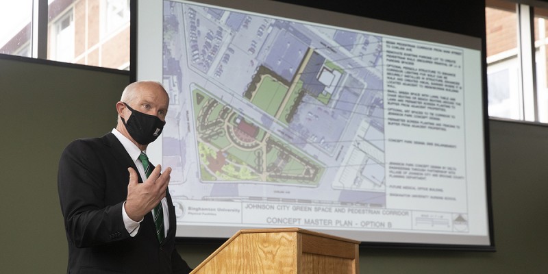
The Johnson City Revitalization Project, which began in 2016, has used GIS and story mapping to track and analyze what has happened to the village in the past five years. Story mapping brings together maps, images, video narratives and other content to tell the story of what has transpired.
Stenger recounted how he had left New York state in 1979 for nearly three decades, and when he returned to Upstate New York he was shocked at the transformation that had occurred while he was gone. “One-third of the manufacturing jobs were lost; factories were abandoned,” he said. “So when I got to Binghamton I said I would try to do something to help. It will take a long time, but we’ll do the best we can.
“That’s why I call this a recovery process,” he said.
The Village of Johnson City became a focus of this recovery, with the University’s establishment of its School of Pharmacy and Pharmaceutical Sciences, and more recently its relocation of Decker College of Nursing and Health Sciences, to the new Health Sciences Campus in Johnson City.
Using images gathered using GIS technology, Stenger explained how the University has purchased, built, renovated and demolished various properties to expand the University’s presence in Johnson City.
“If you look at the total area from the Gannett Building to the Health Sciences Campus, it’s not a walk you’re likely to take,” Stenger said. “I’ve never made that walk from one side of the Johnson City downtown to the other end, but that path is key as we look to build the village’s recovery.”
Stenger spoke of next developing a park area with a walkway to connect the Health Sciences Campus to Main Street, providing a path from the campus to major housing and services. “Walking in a safe manner is critical,” he said.
“We’re creating an outdoor place where students can sit and gather, have lunch, but also a path to Main Street,” he said. “Much has already been purchased. Our goal is to tie it into other spaces and make it a very active area.”
As he used drone photos to point out how far the University has come in aiding the recovery of Johnson City, Stenger said the plan is about 80% realized.
“This park is the next challenge,” he said. “John Frazier did focus groups with pharmacy and nursing students and these are some of the words that rose to the top: shops, study, students, welcoming, benches, sidewalks, crosswalks. The biggest word was safety, and that factored into how we selected the properties we purchased. The next step is preparation of the park.
“It’s just a concept right now because we don’t have the funding for it, so will take a year or two to bring to fruition,” Stenger said. “We’ll have around 2,500 students, faculty and staff coming to this area every day, from pretty much zero. We think we’re on the way back for Johnson City, and we’re heading in the right direction.”
Following Stenger’s presentation, Frazier used a video to highlight the areas that have been purchased and what has been demolished. “You can appreciate the amount of debris that has been taken away to clean up these parcels,” he said. “It’s been a very big effort.”
Stenger also said there were a few important guidelines that the University has followed throughout this recovery process.
“First, we never purchased a house that was occupied,” he said. “And we never used eminent domain. We never said that we would take a property for the greater good.
“We also always paid fair market price,” he added. “And that escalates after you buy the first property, and then second one. All in, including construction of the pharmacy building, renovating the nursing building, the research and development building that’s out for bid and the senior care clinic totals a $133 million investment. Almost all of those funds are from the Upstate Revitalization Initiative that we won and that was created by the past governor in order to recover the upstate economy. No other dollars other than the Ford gift dollars for the senior clinic were used. That’s why it takes so long.”
Also during the presentation, Kevin Heard, assistant director of the GIS Campus Core Facility, spoke of the state of GIS on campus, noting that there is a waiting list for the courses in GIS, and reviewed the software the facility is currently using that allows users to create maps, story maps, web mapping applications and more. “We granted over 600 licenses in the past two years, so it’s being heavily used across campus,” he said. “And our lab software has shifted to using a virtual desktop, which is much more cost effective.