Binghamton University innovates new technique to detect plastic landmines
Using consumer-grade technology, the method doesn’t require an Internet connection — a plus for conflict zones

Today’s anti-personnel landmines are small in size and often have a plastic casing that standard metal detectors are unable to register. Geophysical techniques such as ground-penetrating radar, magnetometry, and electromagnetic induction are significantly less effective with plastic mines than with those created from metal.
Of particular concern are so-called scatterable landmines, designed to be deployed over wide areas. One widely used mine is the Soviet-era PFM-1. Designed to fall like maple seeds from the sky, the PFM-1 — known as the butterfly mine, for its distinctive shape — follows a brutal logic.
“It’s harder to take care of a wounded soldier than a dead one. They’re meant to hurt, not kill,” explained Binghamton University Associate Professor of Earth Sciences Alex Nikulin. “They’re specifically designed with that purpose in mind, and their entire construction is meant to evade detection.”
A new technique uses machine-learning algorithms — artificial intelligence (AI) — to detect these plastic landmines over wide areas. Led by geology alumna Sharifa Karwandyar, MS ’25, Associate Professor of Geography Thomas Pingel and Nikulin, “Deep Learning and Multiview-Based Detection of Scatterable PFM-1 Landmines: Performance, Out-of-Sample Evaluation, and Field Readiness” recently appeared in the journal Geomatics.
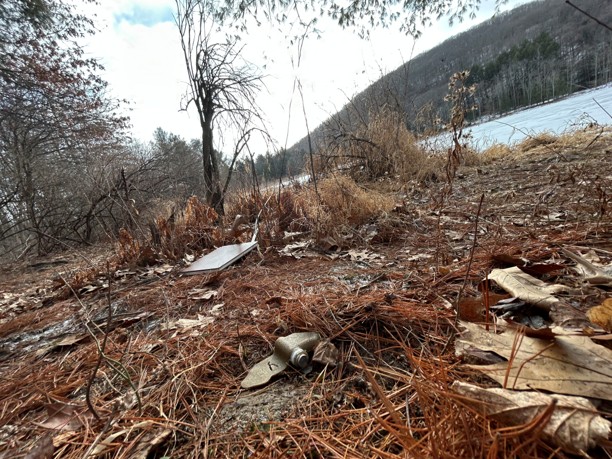
In active warzones such as Ukraine, scatterable landmines often lurk close to the surface; in post-conflict regions, however, they may become buried or concealed in the landscape over time, Karwandyar said. Since plastic landmines are typically the size of a cell phone, drones used in detection must fly low to the ground — 10 or 20 meters — so that the sensors can achieve maximum resolution.
“This is a first-pass analysis to determine whether a locality is potentially a suspected hazardous area,” Karwandyar said. “That falls in line with the standardized process for landmine detection.”
In the field
In her master’s thesis, Karwandyar used a drone-mounted camera and software to stitch together low-resolution images. Those images were then run through You Only Look Once (YOLO), a machine learning algorithm that helped identify potential landmines.
The researchers trained YOLO’s object detection algorithm using inert PFM-1 mines, as well as 3-D printed replicas. Then, they placed the mines in different parts of Binghamton University’s Nature Preserve, building a dataset of what a PFM-1 mine would look like in various environments, angles, settings and lighting conditions, Karwandyar said.
“We trained two different YOLO models to understand how we can make something like this field-ready,” she said. “One model was trained only on the PFM-1 landmines, and the other was used to identify the PFM-1 and additional random objects using a standard data set.”
The second model resulted in lower performance values, which most likely reflect real-world results, she said. After all, cameras also pick up elements of the environment, such as leaves.
Much of the processing work occurs during the algorithm training phase, which lasts several hours to a day, depending on the number of images involved, Pingel said. In the field, deployment would require only a lightweight consumer-grade laptop, drone, and camera.
“Sharifa’s work has emphasized processing data in either real time or near real time, so that you can tackle these things in the field,” Pingel said. “There’s no need to collect data and then bring it back somewhere to process and examine it.”
That’s a major plus: both active- and post-conflict nations typically have problems with Internet connectivity, whether through a lack of intact infrastructure or active GPS and signal-jamming, as seen in Ukraine. To be useful in the field, a system needs to operate without relying on a connection — which this method does.
The field relies on individuals who have been trained in demining techniques, and on community members with an in-depth knowledge of the terrain. Object-detection models such as this one may streamline the search process, making it both easier and safer.
“With landmine detection and humanitarian work in general, a lot of times there’s a disconnect between what folks work on in the lab and the realities of the field,” Nikulin said. “By communication with the (non-governmental organizations), we’re able to bridge that, and we know this will work in the context of the field.”