Eye in the sky: Drones play important role in archaeological research

Under mounds and hillocks and old farm fields, traces of the past remain — if you have the equipment to find them.
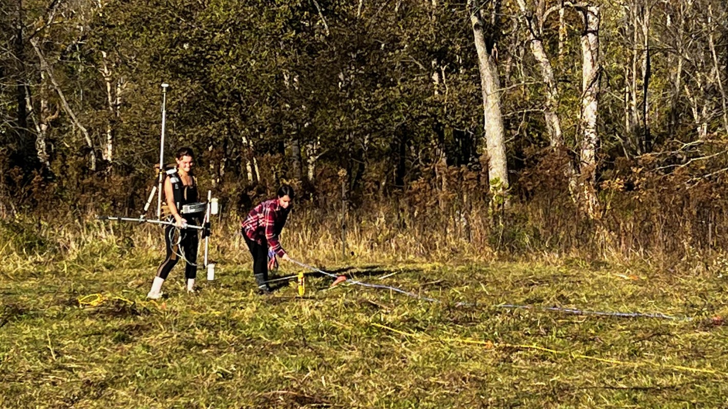
In October, a team of Binghamton University researchers brought an eye to archaeological research sites in Louisiana and Missouri. Professor of Anthropology and Environmental Studies Carl Lipo, Research Assistant Professor and Geophysics and Remote Sensing Laboratory Director Timothy de Smet and three students — anthropology doctoral candidate Petra Peretin, environmental studies major Jalissa Pirro and geological sciences major Madison Tuohy — carried sensors and flew high-tech drones over mounds and fields, scanning the ground with radar, magnometry and other mapping techniques.
“It was a humbling experience to say the least. When you’re sitting in a lab and processing data, it can be easy to forget the work that gets put into collecting it, which makes me all the more appreciative for the people who do that work,” said Pirro, a senior.
The team worked with doctoral candidates Erin Whitson and Tiffany Raymond, who are conducting research in Missouri and Louisiana, respectively. The trips were funded by the Institute for Genocide and Mass Atrocity Prevention and the Binghamton University Foundation.
At the Poverty Point site in northeastern Louisiana, they used ground-penetrating radar to examine the potential structure within a giant mound, believed to have been constructed more than 3,000 years ago. The question: Was it built in a single effort over a period of months or in stages?
“Our work intends to examine that claim and see if we can detect internal structures that would potentially come from multiple construction episodes,” said Lipo, Harpur College’s associate dean for research and programs. “We also did work in an area where we had detected a massive subsurface ‘ring’ feature that was previously unknown.”
The team also conducted radar and magnetometry analysis in an area where historic African-American burials are potentially located to contribute to the conservation and documentation of that part of the site, Lipo said.
Tracing the Trail of Tears
In Missouri, the team aided Whitson in finding Cherokee campsites used during the Trail of Tears. The team conducted a magnetometry survey, which measures variability in the earth’s magnetic field over a landscape as a way to detect what’s below the surface, as well as drone-based light detection and ranging (LiDAR) and photogrammetric mapping.
The forced movement of Cherokee groups from the southeastern United States to reservations in Oklahoma – known as Trail of Tears—began in 1837. The first party traveled through the bootheel of Missouri, then up through the center of the state before looping town through the southwest.
“Missouri has more miles of the Trail of Tears than any other state, but it’s the least well-known portion,” explained Whitson, a Missouri native. “We know that the vast majority of the Cherokee who came through the following year, in 1838, used that same route.”
The largest groups were rounded up by soldiers in the spring of 1838 and placed in “depots,” which functioned as concentration camps. Many were not permitted to take or sell possessions, which were often stolen — along with their homes — by their non-native neighbors. Because of a horrific drought that likely claimed lives in its own right, their westward journey didn’t begin until October.
“Anyone who has ever played the game Oregon Trail knows that October is not the time you start a cross-country journey on foot, but they had to because they didn’t have any options. They weren’t given more time,” Whitson said.
More than 10,000 Cherokee ended up making the journey over three years’ time, but only two eyewitness accounts remain, both written by white men: one a military officer and the other a missionary.
Sicknesses emerged and dogged the Cherokee during the entire westward journey. By the time they hit the Mississippi, sheets of ice were floating on the river, leaving them on the east side for weeks. When they reached the Missouri trail, many were felled by what is believed to be cholera.
“There were so many sick people that they couldn’t fit them in the wagons that they had, so they talked with the locals, who advised them to go two miles up the road to a schoolhouse, which they used as a makeshift field hospital for another seven days before they left and went further west,” Whitson said. “My work is trying to figure out where these encampments were.”
Whitson and her fellow researchers are working with Cherokee descendants on the project and have agreed to avoid human remains whenever possible. The drone-based scans are playing a crucial role, allowing researchers to see what lies below the surface without disturbing any soil.
If objects are discovered, Cherokee para-professional archaeologists will help recover and identify them, and the tribe will decide whether to keep or reinter the artifacts. All the project’s data will be shared with the Cherokee, the National Park Service and state historic preservation officers to ensure the integrity of the sites.
The research has encountered unexpected delays: from the coronavirus pandemic to forest fires and even nesting eagles who were likely to attack the drones. Whitson is still processing the data but has some potential clues as to the location of the schoolhouse, she said.
Pilot and ground crew
Applying geophysics to archaeological research was a new experience for both Pirro and Tuohy, who eagerly learned about the fieldwork sites. Both trained to use the drones and equipment at Binghamton; Tuohy has the Federal Aviation Administration certification needed to fly the drones.
During the research trip, Tuohy piloted the smaller drones for photogrammetry, as well as the larger ones needed for geophysical remote sensing data collection. Pirro, who originally started working in the geophysics lab during the First-Year Research Immersion program, played a ground-support role, setting up the equipment and clearing the land of obstructions that could impact the data. To prepare for the collection of magnetometry or ground-penetrating radar data, she helped lay out transects:long ropes laid out in parallel lines to guide the survey instruments.
The realities in the field are far different from the more controlled conditions back on campus, and require troubleshooting and persistence, Tuohy said.
“Whether it is a broken drone or a rare electromagnetic phenomenon, you never know what you’re going to encounter in the field, but we had to be ready to face these problems head-on!” she said. “I learned the importance of being able to think on my feet and come up with creative solutions to all types of situational challenges.”