Take the ridge: Project to aid the recovery of missing servicemen reaches Guam
Techniques used to discover Maya ruins are revealing hidden WWII battlefields

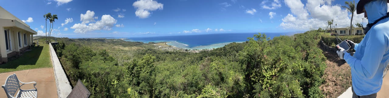
From the beach at Asan, the U.S. Marines faced a daunting task: battle their way up the heights to Adelup Point, occupied and fortified by the Japanese.
The same technology used to locate Maya ruins amid the jungles of Guatemala is recreating the scene of the 1944 Battle of Guam in intricate detail, potentially leading to the recovery of missing servicemen.
This is the second World World II-related project Binghamton University Anthropology Professor Carl Lipo and Associate Professor of Geography Thomas Pingel have worked on in collaboration with the Defense POW/MIA Accounting Agency (DPAA) and the International Archaeological Research Institute (IARI). Last fall, they conducted research at Guadalcanal in the Solomon Islands.
“Our goal was to generate high-resolution topography so that we could reconstruct the detailed landscape which people had to go up,” Lipo said of the Guam project. “Most of the areas where people are lost are remote settings with rough terrain and jungle.”
To do so, they used LIDAR from unmanned aerial vehicles. LIDAR, short for light detection and ranging, uses a quickly spinning laser to send beams to the ground below; some of those beams make it through the leaves of the forest canopy, reflecting upward. This data enables researchers to measure the ground distance; flying systematically over an area can provide an image of what’s beneath even the densest forest, said Lipo, who has used drones in previous research on Rapa Nui (Easter Island).
The Guam mission required a larger drone than the one in the Solomons, powered by large lithium-ion batteries that can’t be taken on an airplane; thankfully, they shipped to the site on time. Getting the necessary permissions to fly was tricky since the battlefield is located in a national historic park; the flight path also included a naval base and Guam International Airport, Pingel said.
The U.S. Marines recaptured the island during the Battle of Guam from July 21 through Aug. 10, 1944. During the campaign, around 1,700 Americans were killed and 6,000 wounded; Japanese deaths totaled around 18,000.
Their research centered on Bundschu Ridge, a steep slope up to the high ground held by the Japanese, who had invaded the island in 1941. It’s named for Captain Geary Bundschu, who led the assault and died on the third day. Steep and rocky, the ridge is pocked with caves — ideal spots for carefully positioned machine-gun nests and hidden combatants.
Historical photos show the region — which had been blasted by artillery — as largely open terrain. In the 80 years since, thick palm trees, bamboo and vines have covered the battlefield, shielding it from view.
“What’s cool about doing these projects is that you’re standing on a landscape and capturing what people saw and did,” Lipo said. “They were coming up this crazy terrain with guns blazing at them and grenades being rolled down the hill.”
Back at Binghamton
To build a highly detailed view, Pingel and Lipo needed data points from the ground every 10 centimeters. They devised a way to optimize their drone flights, building on their experience in the Solomon Islands.
A slow, tight pattern allowed for the overlap needed to build intricate detail. All told, they flew more than two dozen missions, all of which had to be aligned for a clear picture.
“We flew all day and crunched numbers all night, and went back at it again the next day,” Pingel said.
Even more painstaking work is ahead: The flights generated around 3 billion data points, which now need to be processed and filtered. The topographic images will then be tied into historical data about troop movements on a daily or even hourly basis to figure out where people were at any given time. DPAA can then use this information to locate the remains of lost soldiers, Lipo said.
Research experiences in the Pacific islands could potentially benefit Binghamton students. Remote sensing techniques are currently in demand in a range of industries, Lipo and Pingel pointed out, and they hope to foster these skills in the classroom.
“There’s a big opportunity for students to learn what we’re doing and apply it to different domains,” Pingel said. “Our goal is to build a curriculum that supports student education so they can step into these roles in companies and start their own businesses.”