About:
Grades/Ages: Grades 6 - 7
Instructor will relate the principals and mechanics of sediment deposition, site dating techniques, the correlation between time and soil levels, and possible site/soil disturbance. In groups of 3-5 people, students will use soil "keys" to match a known date and soil context to soils on the poster. The keys provide a date to apply to different features on the poster. Students will take this information and concepts learned from the discussion to complete the worksheet.
Materials:
Copies of the soil levels poster for each group. Poster may be printed out at any size. Legal or 11X17 is best for visibility and for sharing. If you increase the poster size, remember to increase the sheet of keys the same amount to allow for best matching. PREVIEW A set of soil "keys." The instructor will have to cut out a set for each group. There are 2 sets of keys, and 2 teachers keys on each sheet. PREVIEW Questions worksheet. Pencils.
Preparation:
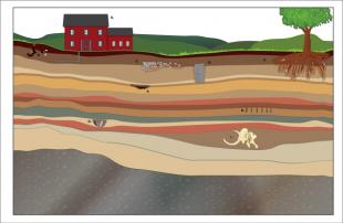
A variety of environmental factors contribute to the deposition of sediments on the surface of the earth, including erosion by physical and chemical weathering, wind, glaciers, flooding, and volcanic activity. A heavy buildup of sediments is often found in valleys and the flood plains near rivers, where people have tended to settle. As human activities in these areas continue over the years, evidence of their activities are sometimes left in the soil. As sediments are deposited, evidence of these human activities are buried. Over time, newer evidence of human activities are deposited on top of the old, which will in turn be buried by new sediments. The result is that the newest deposits are usually found nearest the current soil surface, and the soil with the oldest materials is found at the lowest depths. The study of soil(and rock) levels is called Stratigraphy.
The most obvious analogy to stratigraphy is a multi-layer cake. The first layer is layed down first. Then another layer is place on top of that. More importantly, if you cut a slice in that layer cake, you would be able to see the layers built up on top of one another.
Different episodes of sedimentary deposition can be seen as different layers of soil, both in color and texture (soil type). Sometimes large-scale events such as forest fires, volcanic explosions, or catastrophic flooding mark a specific point in time (and a layer in the soil). If we know when a certain event happened, such as the explosion on May. 18th, 1980 of Mt. St. Helens and its widespread fallout of ash, and we can identify it as a layer in the soil, we can group all the artifacts and materials in a layer to that period in time. Of course, archaeologists do not usually know the exact date of an event. Relative Dating Techniques
When excavation starts on a site, archaeologists carefully remove the layers (strata) of soil to reveal artifacts and features. As they cut into the soil, they painstakingly note the color and texture of each layer. After completing the excavation of the site, drawings of the walls (profiles) of the excavated areas are all combined into one large map. This gives archaeologists a view of the entire site's soils and can show where artifacts lie in time and space. Each layer is given a code to identify it. When archaeologists cannot get dates from absolute dating methods such as radiocarbon or thermoluminescence, they must rely upon relative dating. By comparing soils from nearby sites or different areas at one site, the levels can be placed in sequence from the earliest levels at the bottom to the most recent levels at the top. This concept is called the "Law of Superposition." When artifacts or features are found, they are grouped with all other artifacts found in that soil level. Artifacts found in the same soil level are believed to be of the same time period. They were deposited at that level at the same point in time. Therefore, an artifact in an upper stratum is considered to be more recent than one found at a lower depth. The study of soil(and rock) levels is called Stratigraphy.
Sometimes, there are clues that can give a more specific date to a stratum. Some artifacts have properties that identify when it was made, such as the shape and size of a projectile point, or the color and glaze of a piece of ceramic. These not only give us a more proximate date for the artifact, but a date for all other artifacts in that same layer of soil, and all artifacts and features found in matching soil types in different areas of the site, and other nearby sites. Sites found in the historic period often yield artifacts that can be dated in this manner, as we have a written record to match up with the material record.
Disturbances
While the Law of Superposition is an important method used for dating the artifacts found on a site, archaeologists must also determine if that site has been disturbed in anyway. Most archaeological sites are subject to a wide array of disturbances. External forces such as erosion, gravity, earthquakes, burrowing animals, plant/root growth, human-made structures, chemical alteration, and many other natural or human made activities can change, move, or mix up the original layers of stratigraphic levels. This could be the result of a natural disturbance, such as a root or an animal burrowing into the ground. Humans can create the same effect by digging holes or pits. Artifacts that are moved into or fall in those spaces would then be found in a lower stratigraphic level than where they were originally deposited. In these cases, an artifact can possibly be found below an older level.
Usually, disturbances are superficial and contained in one area of the site. In the case of larger events, a site's integrity can be destroyed, especially when soil levels have been turned over or moved.
Because it is so important for archaeologists to be able to recognize subtle differences in soil color to determine disturbances, archaeologists must take careful and precise notes.
Lesson Objectives:
- Understand how archaeological sites are formed
- Understand the concepts of sediment deposition.
- Understand how archaeologists use soil levels to learn about the age of a site.
- Learn how different forces can disturb the context of a site.
- Critically answer questions based on the activity.
Documents
Procedural Step:
Students will learn the basics of soil deposition and how archaeologists use soil levels to assign dates. They will learn that archaeologist's cannot always know the exact date of an artifact or feature, but can often find out which part of a site is older than another. In addition, students will understand that sites can be disturbed by a variety of forces, and these forces can affect how we perceive the relative dates of the site.
- Students will work in groups of 3-5.
- Each group receives a strata poster and a packet of "soil keys."
- Each student receives a copy of the worksheet.
Groups will work together to use the soil keys to identify the dates. Students take turns reading the text on each soil key to the other members of the group. Each key can be held onto the poster and dates assigned based on the clues. Each worksheet has an area to fill in the dates and answer a few questions about the concepts. Some of the labeled items are not actually cultural features, but reflect natural disturbances. A few of the items may catch the students, as they exist in several of the layers of soil. The feature or artifact (such as a storage pit or longhouse post-mold) could be associated with the higher levels, as it would have been cut out of existing ground surfaces in ancient times.
The instructor will decide when the activity has ended and begins a class discussion of the results.