The juncture of major rivers served as important settlement locations, travel corridors, and sacred places for thousands of years of Native American history. The confluence of the Chenango and Susquehanna Rivers is no different. Archaeological investigations over the past 50 or more years identified traces of past Native American camps and villages that once dotted the banks of these two rivers, particularly near the confluence area. Many more habitations probably existed but have been erased by historic neighborhoods and other developments. The evidence uncovered by archaeological investigations allows us a glimpse back in time at the communities that once flourished near the confluence. This tour stop shares what archaeologists have learned about early Native American peoples who called this region home during the past 10,000 years.
Elk crossing the Chenango River (from Hunter to Farmer: 10,000 Years of Susquehanna Valley Prehistory; illustration by Margot Weisman).

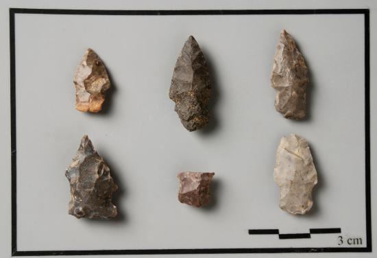
Early projectile points from the Roberson Site (note the diagonal breakages).
By 2,000 B.C., the site yielded the first evidence of a substantial camp. Archaeologists uncovered thousands of stone tools, the by-products of making those tools, and the cooking pits that people used to prepare their meals and preserve their food. Several projectile point styles classified as Late Archaic (such as Brewerton, Lamoka, and Vestal) support three radiocarbon dates averaging around 1900 B.C. Excavations several miles downstream at the Castle Gardens site in Vestal, documented that both the Lamoka and Vestal point styles co-exist within the same archaeological soil layers. Some researchers have interpreted this to mean that the point styles could represent different cultural or ethnic groups who came together for trade, social or political reasons. The side-by-side existence of these two point styles, whatever this may represent, is a theme repeated at several sites in the region.
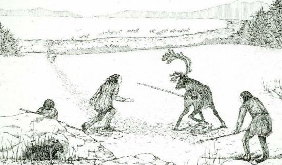
Archaeologists discovered the earliest Native American community at the confluence during excavations in the back yard of the Roberson Museum and Science Center (northwest quadrant of the confluence). Around 8,000 to 10,000 years ago, a group of hunters visited this area. There is no evidence that they camped here for any length of time, but they left behind broken projectile points (the stone tips of spears, darts, and javelins). Several points were broken on the diagonal, suggesting that they snapped off while still in an animal pierced by the weapon. Not much more is known about these hunters, but their presence at the confluence may correspond to their pursuit of a herd of animals slowed by the crossing of the rivers.

Roberson Late Archaic camp (from Hunter to Farmer: 10,000 Years of Susquehanna Valley Prehistory; illustration by Margot Weisman).
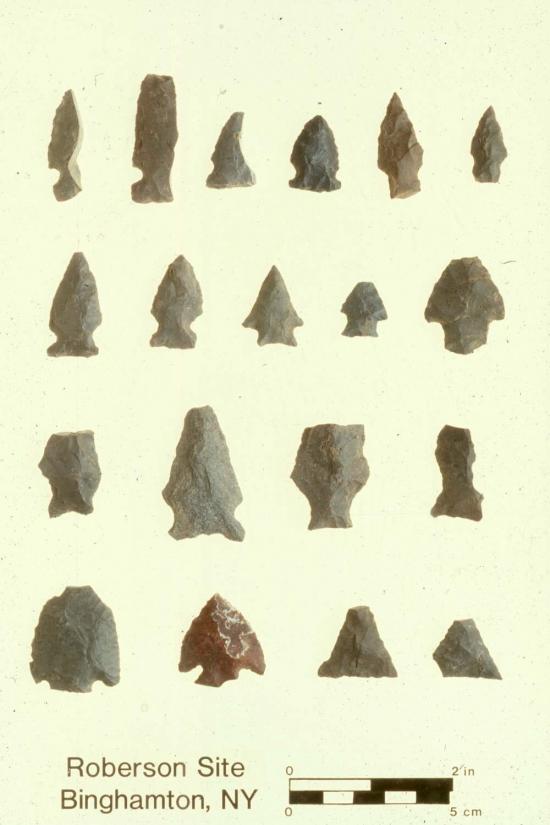
Late Archaic projectile points (top two rows).
By 2,000 B.C., the site yielded the first evidence of a substantial camp. Archaeologists uncovered thousands of stone tools, the by-products of making those tools, and the cooking pits that people used to prepare their meals and preserve their food. Several projectile point styles classified as Late Archaic (such as Brewerton, Lamoka, and Vestal) support three radiocarbon dates averaging around 1900 B.C. Excavations several miles downstream at the Castle Gardens site in Vestal, documented that both the Lamoka and Vestal point styles co-exist within the same archaeological soil layers. Some researchers have interpreted this to mean that the point styles could represent different cultural or ethnic groups who came together for trade, social or political reasons. The side-by-side existence of these two point styles, whatever this may represent, is a theme repeated at several sites in the region.
Temple Concord
Very near Roberson is the Temple Concord site, discovered to the rear of the Temple’s property (now covered with deep fill). Excavated in 1965-66 by Binghamton University, the site represented a time capsule of 5,000 years of Native American settlement. According to the New York State Archaeologist (Dr. Robert Funk), Temple Concord produced “the largest subsurface collection of Brewerton-related materials in the Upper Susquehanna.” The Brewerton layer of the site contained 25 side-notched points, some with serrated knife-like blades, a unique collection for the Susquehanna Valley. Brewerton is another Late Archaic cultural community, different from Lamoka and Vestal. Does Brewerton represent another cultural or ethnic group that visited this region for trade or other purposes? Archaeologists cannot answer this question for now, but hope to discover similar Brewerton sites in the future to learn more about this community of hunters and gatherers.
Among the other layers of camps at Temple Concord was one with points classified as Transitional. Around 1500 B.C. (or 3500 years ago), the Susquehanna Valley experienced a major change in cultural communities that lived in this region. Small, narrow points were replaced by large, broad styles, some of which were made from stone not native to the Susquehanna Valley. Jaspers and rhyolites are rock formations that occur much farther to the south in the Lehigh Valley of Pennsylvania. The Transitional is also the first time that people experimented with using stone bowls for cooking in and over fire pits. Steatite (or soapstone) is also not found in this region. People had to travel or trade to get this material from southern Pennsylvania to as far south as Georgia. The Susquehanna and Chenango Valleys contain many sites with Transitional points and steatite cooking vessels, including other sites near the confluence, such as John Moore Farm.
John Moore Farm
Binghamton University archaeologists excavating the John Moore Farm Prehistoric Site.
Lamoka points (top row) and Vestal points (bottom).
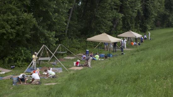
The John Moore Farm site is a series of seasonal camps positioned adjacent to the Susquehanna River near the MacArthur Elementary School. Archaeologists from Binghamton University excavated the site as part of a proposed walking trail planned by the Department of Transportation. Excavations produced over 11,000 lithic (stone) artifacts, including stone tools (points and scrapers), the by-products of making those stone tools, and steatite (soapstone) bowl fragments. The style of the points suggests that people visited this area to hunt and fish over a 3,000 year period (4000 – 1000 B.C.), which covers the Late Archaic and Transitional. However, most of the artifacts are associated with the Transitional period, and four radiometric dates cluster within the range of 1600-1500 B.C. The tools were mostly made from locally available chert, a flint-like stone. However, a few pieces were rhyolite and yellow jasper (one of which was heated to a deep red color). This local community had to trade with southern groups to get this material, or they traveled and traded for the exotic items. The confluence served as a transportation hub for peoples traveling north and south, and allowed trade materials (and people) to move into the Southern Tier region.
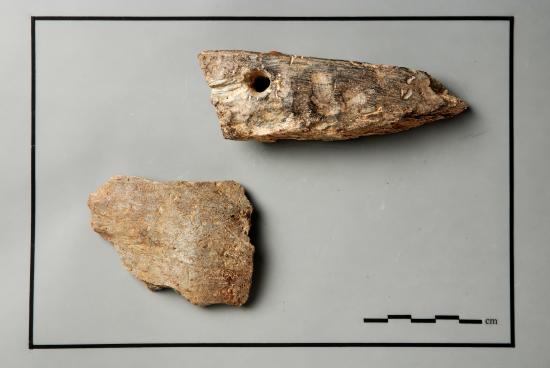
Steatite (soapstone) bowl sherds from John Moore Farm.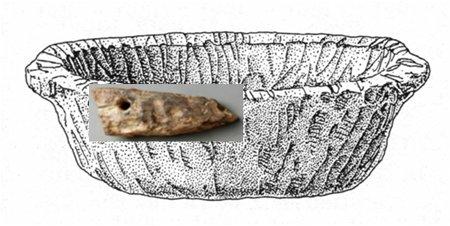
Sherd superimposed on an illustration of a bowl.