4.1 Environmental Context
The Newtown battlefield is located in Chemung County, New York with portions of the battlefield in the Towns of Ashland, Chemung, and Elmira. The terrain consists of flat-topped hills and ridges separated by large valleys (USDA 1973: 96). It is part of the southwestern plateau section of New York in the Allegheny Plateau physiographic province (USDA 1973: 96). The range in elevation between the ridges and the valleys is about 200 to 800 feet depending on the size of the valley (USDA 1973: 96). Glacial action and the Chemung River define the topography and soils of the Newtown battlefield. This area of New York was completely covered with an ice sheet during the Pleistocene. The presence and recession of this ice deposited a layer of glacial till consisting of unsorted clay, silt, sand, gravel, and boulders across the entire county (USDA 1973: 96). Glaciation initiated the formation of ridges and valleys in the county. The Chemung River and its tributaries helped through erosion to better establish the landscape.
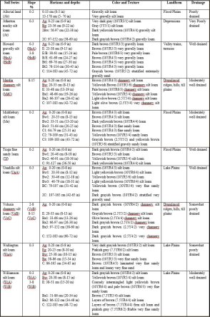
Glaciers and drainages established two main soil types in the vicinity of the battlefield (Figure 11). The ridges and hills contain Arnot, Howard, Lordstown, Mardin, Valois, and Volusia soil series. These soils are channery silt loams related to glacial till. The valleys consist of alluvial land, Middlebury, Tioga, and Unadilla silt loam soil series, which are alluvial sediments associated with streams, creeks, and rivers. The areas of alluvial sediments in the valleys present the most possibility for deep deposits. Depending on the rate of deposition, the battle related deposits might be buried under later flood or stream deposits. Deep deposits may interfere with metal detecting or magnetometer survey. Areas of heavy stream flow may have eroded cultural deposits. As such, the areas of alluvial soils present some issues for identifying battle related deposits. The hills and ridges had little deposition after the glacial till and so battle related deposits would likely be identifiable near the surface. Other soil series present in the battlefield include Atherton, Wallington, and made lands. Atherton soils are related to small depressed areas in the glacial plain and are poorly drained. The result is a high water table and mucky wetlands environment. Wallington soils occur on stream terraces or lake plains and are made up of lake laid deposits. The water table is often high during the spring or periods of high precipitation (USDA 1973: 90). Atherton and Wallington soils are mostly restricted on the battlefield to the swamp defining feature. These soils are stable in terms of deposition and as such, battle related deposits should be identifiable with little difficulty. [text deleted] The presence of this fill most likely means battle related deposits have been deeply buried, and/or scraped away resulting in limited integrity remaining. [text deleted] Table 3 details the contexts and descriptions for these soil series.
Table 2. This table was intentionally deleted per the requirements of the Archaeological Resource Protection Act (16 U.S.C. 470hh) and its implementing regulations (49 FR 1027, Jan. 6, 1984).
4.2 Post Battle Land Use and Alterations
Agriculture has served as the main use of the land including and surrounding the Newtown Battlefield since the American Revolution. Within the ridges and valleys of Chemung County, Revolutionary War veterans and other Euro-American settlers replaced the prior Native American villages creating agricultural communities across the region. The area surrounding the Newtown Battlefield had a Native American presence from at least the Archaic period to the Revolutionary War (Hohman et al. 1997; Knapp 2000; 2002; Knapp et al. 2003; Loren et al. 1996, 1997). Villages, farmed fields, and trails characterized this landscape shortly before and during the Revolutionary War. With the end of the war, these lands became enticing to the citizens of the new republic who saw the fertility and possibilities of the landscape themselves during the campaign or who heard about the region from others. Euro-American settlement started in earnest immediately after the Revolutionary War (USDA 1973: 95). Many of the earliest settlers were veterans of the Continental Army, including the family of Isaac Baldwin Sr. (Grills and Zlotucha Kozub 2007). Their settlements were primarily agricultural with small villages and a basic industry based on mills and blacksmiths centered on the county's creeks and rivers.
The landscape related to the Newtown Battlefield and the Sullivan-Clinton campaign aided early settlement. Not only were many of the settlers veterans, they used the paths followed by the campaign to establish transportation routes. The Newtown battlefield was located along an established trail connecting various Indian villages in Pennsylvania and New York. With the villages destroyed by the Sullivan-Clinton expedition, the trail continued in use by Native Americans, and by early settlers to the region. [text deleted] From this road, settlers established their farms and residences.
Two farming families, the Baldwins and the Lowmans, provide good examples of the use of the battlefield during the 19th century. Both families were prominent in the early history of the region and in the landscape's development following the American Revolution. PAF has excavated farmstead sites related to both of these families (Knapp et al. 2003). The excavations of these sites concentrated on the household occupations from the early 19th century into the 20th century.
The Baldwin family was one of the original settlers in what would become the Village of Lowman after the Revolutionary War. Issac Baldwin, Sr. and his family were originally from Connecticut and settled in the Wyoming Valley of Pennsylvania in the 1770s as part of Connecticut's claim to the area. The territorial conflict between Connecticut and Pennsylvania's claim over the Wyoming Valley led to the First Pennamite War (1769-1771) (Grills and Zlotucha Kozub 2007). The Baldwins most likely were involved in this conflict as Connecticut settlers. During the American Revolution, a more disastrous episode occurred with the Wyoming Massacre. This event probably inspired Issac and his four sons, Thomas, Rufus, Waterman, and Isaac Jr. (Lowman 1938:221) to join the Continental Army. Issac Sr., Issac Jr., Thomas and Rufus joined Captain Simon Spalding's Wyoming Independent Company, while Waterman joined Captain Robert Durkee's company near Easton, Pennsylvania (Lowman 1938:214). The Baldwins who joined Capt. Spalding's company were part of the Sullivan-Clinton campaign and saw firsthand the fertility of the Chemung Valley. After the war, Issac and his family settled in the Chemung Valley tiring of the conflict in the Wyoming Valley between Connecticut and Pennsylvania (Grills and Zlotucha Kozub 2007).
The Baldwins were primarily farmers in the Chemung Valley. They supplemented their farming income by working as innkeepers, running a general store, operating some of the early mills in the region, and a liquor distillery. During the war, Waterman Baldwin had served as scout and been captured by the Seneca. The Seneca war chief, Cornplanter (Garganwahgah) adopted Waterman and in this position, Waterman learned to speak Seneca. Waterman served as an interpreter for Colonel Thomas Proctor in post war negotiations with Cornplanter. On this expedition, Col. Proctor and Waterman Baldwin stopped at Issac Baldwin Sr.'s inn and provided a glimpse of the battlefield's landscape after the battle.
Dined at Mr. Isaac Baldwin's, and halted for the night, and reviewed the ground on which the British and Indians were entrenched, for better than a mile, against the forces under the command of Major General Sullivan. I also saw many traces made by our round and grape shot against them, and a large collection of pieces of 5 1/2 inch shells, which I had the pleasure of formerly causing to be exploded amongst them. Expenses at Mr. Baldwin's for present diet, provisions, and forage, 53s. 910d. (American State Papers, Indian Affairs, 1792:150).
Waterman did not move to the Chemung Valley until 1798 (Lowman 1938:222).
With the close of the 18th century, the Baldwin family had started to retreat from the Chemung Valley. Silas and Waterman were the only Baldwins listed on the Chemung County tax rolls for 1799 (Grills and Zlotucha Kozub 2007). The Baldwins had sold their property by the end of the 1700s, but established the basic settlement that would become the Village of Lowman. Their farms, stores, residences, and early roads initiated a change to the battlefield's landscape. They cleared fields and allowed for increased settlement and movement through the area. The Lowman family who took over the lands of the Baldwins, and other early settlers would more dramatically reshape the battlefield's environment.
The Lowman's occupation in the area of the battlefield began at the end of the 18th century. Jacob Lowman was a river trader from Middletown, Pennsylvania. In 1792, he established a logging business at Tioga Point, Athens, Pennsylvania. He moved this enterprise to the Village of Chemung and later the area of the Newtown Battlefield, the village of Lowman in 1799 (Knapp et al. 2003). Jacob Lowman bought his initial property from a merchant, Guy Maxwell, in 1799 (Knapp et al. 2003). Maxwell bought the property in 1797 from William Wynkoop who had previously bought the parcel from Roger Conate. Conate was the original patent holder for the property and presumably a Revolutionary War veteran. He continued to buy land in the vicinity and at 1799 had a total acreage of 386 ha (953 acres) (Knapp et al. 2003: 138). Additions to his property continued into the 19th century. His industries included logging, trading, a whiskey distillery, and a dairy farm. These enterprises most likely had an effect on the area of the battlefield. His logging probably made the biggest alterations to the landscape. It is uncertain how much of the area of the Newtown battlefield was wooded. The Run or area between Brigadier General Edward Hand's light infantry and the British breastworks was cleared (Flick 1929b: 136). Major John Butler also states that the plain to the south of the battlefield was open (Cook 1887: 155). The Continental Army's avenue of approach was probably thick with vegetation as Hand ordered a scout to climb a tree to see further down the trail (Cook 1887: 155). Much of the area in and around the battlefield was probably wooded. Jacob Lowman and the other settlers probably cut down these woods to clear fields, as part of the logging industry, and for domestic use.
Beyond industry and logging, Jacob Lowman and his descendants made the Chemung Valley their home and in doing so helped to reshape the battlefield's landscape. Jacob Lowman built his first house, a log cabin, in 1799 on the south side of the Native American trail (CR-60) (Knapp et al. 2003: 138). In 1819, he built a second house across the road and to the northwest of the original log cabin. This house is still standing along with a second house built for his son George in 1839. Jacob built multiple houses for his children across the area now known as the Village of Lowman. At the time of the Lowman's original settlement, it was known as the hamlet of Baldwin. The name changed in 1862 (Knapp et al. 2003: 138). The Lowmans' houses were clustered along the Native American trail *** as this was the main route through the Chemung Valley. Other families in the area also placed their houses along the trail and the other local roads in the area. Along with residences, farmers also built their outbuildings along the local roads. Household activities most likely had an effect on the areas directly related to these farmsteads. Sheet middens and privies are probably associated with these residences. Archeological testing at the Knapp, Bungalow, and Baldwin sites concentrated on sheet middens related to front yards of some of the earliest farmsteads in the area (Knapp et al. 2003). Twentieth century refuse piles or dumps are also visible on the surface near farmsteads.
The act of farming has had a large impact on the battlefield's landscape. Most of the battle's defining features are located on plowed fields. Farmers have plowed these fields since the early 19th century possibly affecting the position of artifacts and the integrity of features. Another main change to the landscape that is possibly related to farming is the alterations in the drainage patterns in the landscape. Baldwin Creek as it passes through the battlefield has shifted to the west. The shift may have been due to the drainage of fields and other human construction activities. However, the shelf on which the breastworks were built is still evident. Changes in the swamp are identifiable as being the result of cultural activity. At some point in the last 230 years, the swamp has been drained. This is evidenced by a ditch crossing the northern section of the swamp. This ditch and other draining activities have left the northern section of the swamp drier than the wetlands still present in the south. Southern portions of the swamp have also been drained [text deleted]. The majority of the swamp is still intact and soils are still probably damp enough or poorly drained hindering farming. For this reason, much of the swamp is still wooded. The tree line closely lines up with the poorly drained Wallington and Atherton soil series.
4.3 Previous Archeological Testing
PAF has conducted numerous archeological surveys and excavations throughout the Chemung Valley. Most of these have been related to New York State Department of Transportation projects. During the 1990s an extensive survey project and excavation of identified sites [text deleted]
[text deleted] Archeologists for PAF surveyed these areas using a grid of shovel test pits (STPs) at a general interval of 15 m (49 ft) and an interval of 7.5 m (25 ft) in areas of demolished historic structures or structures depicted on historic maps. Metal detectors were not used during these surveys. As such, battlefield deposits were not readily identified. Testing did show a high level of integrity for the majority of the test area's soils and this suggested a high probability for identifying intact cultural deposits.
PAF field crews recovered three artifacts possibly related to the battle during STP survey testing in 1996. The items included a button with a grape motif on the front; this could not definitively be associated with the battle. An iron ball possibly related to artillery canister shot was recovered as well as a fired lead ball with a diameter of 0.44" (11.18 mm) making it a rifle ball. [text deleted]
Figure 12. This page/map was intentionally deleted per the requirements of the Archaeological Resource Protection Act (16 U.S.C. 470hh) and its implementing regulations (49 FR 1027, Jan. 6, 1984).