III. Historical Background
The following will not be an exhaustive study of the overall history of the Battle of Newtown as described in the historic record and by historians. This section is meant to give the reader a general overview of the battle and how it played out on the landscape. A more expansive history of the battle can be found in the previous study (Public Archaeology Facility 2010). [text deleted]
3.1 Prelude
From the outset of the Sullivan-Clinton operation, the Continentals had met very little opposition from Native or Loyalist forces on route, with the exception of the Ambuscade of Chemung on August 13th. Along the entire journey, the expedition fulfilled the orders of General George Washington by burning every Native and Loyalist home and outbuilding along with foodstuffs either in storage or in the fields. Brigadier General James Clinton's forces moving downstream and Major General John Sullivan's force moving upstream on the Susquehanna River converged at the confluence with the Chemung River at Tioga Point. Detachments from each of the regiments were formed into work parties and tasked with the construction and garrison of a new fortification to be called Fort Sullivan (Barr 1932:801).
3.2 Phase I: The March
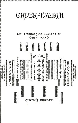
Once the Army broke camp at Tioga, Major James Parr's Riflemen of Brigadier General Edward Hand's brigade moved out to reconnoiter the landscape ahead of the main column, always in search of suspicious landscape features, which could pose the threat of an ambush. Hand's brigade, consisting of formed columns with a company of light infantry, was under the command of Lieutenant Colonel William Butler on the left and Lieutenant Colonel Adam Hubley on the right. Captain Anthony Selin commanded a detachment of pioneers to prepare fords, fell trees, level embankments, fill ditches, and repair roads and trails sufficiently enough to allow the artillery and supply wagons through (Williams 2005:262-263). The remaining "Order of March" was designed to form a hollow square with Brigadier General Enoch Poor's brigade marching in a column of platoons, Hand's brigade on the right, and Brigadier General William Maxwell similarly disposed on the left. A detail of approximately 200 men from each brigade was assigned as flankers to provide security. General Clinton's brigade closed the back of the square in their capacity as a rear guard. Figure 8 provides a sketch of the Order of March as detailed in Lieutenant Colonel Dearborn's journal on the day Sullivan left from Tioga Point (July 31, 1779).
In the field, the Continentals found themselves marching through a difficult landscape. Dearborn writes that the army was confronted with many obstacles as "Our march were very much Impeded by the Artillery and Ammunition wagons which we have to clear a rode [sic] for thro [sic] thick woods and difficult defiles" (Cook 1887:71). The conditions were so difficult that on the morning of August 27th the light corps and pioneers were advanced "some" miles ahead of the encampment to begin the mending and clearing of a trail sufficient for the artillery train (Cook 1887:154; Hubley 1909:284). Twelve hard miles were covered in that three-day march to the Village of Chemung.
Upon arriving at the remains of the Village of Chemung, the scouting parties began reporting on the position of the Loyalist and Indian allies near the Village of Newtown. Lieutenant Colonel Hubley writes that the scouts made "the discovery of a great number of fires, and that they supposed, from the extensive piece of ground covered by the fires, the enemy must be very formidable, and mean to give us battle" (Hubley in Cook 1887:155).
Early on the morning of August 29th the Army struck camp with the intent of engaging the enemy. Samuel McNeil, Brigade quartermaster to General Hand notes that the Light Corps began the advance at 7 a.m. The remainder of the Army began to advance three hours later (McNeill 1893: 755). The light Corps was the first to receive hostile fire from Indian scouts/pickets positioned on the slopes of the natural eskers that run parallel to the Chemung River. In response, General Hand ordered the riflemen forward to neutralize the threat of enemy sniping so his own scouts could make discoveries.
The heavily wooded landscape, interspersed with wetlands, thick undergrowth, and glacial eskers was patrolled by Crown-allied Haudenosaunee. Obtaining reliable intelligence on the British position and their strength was tedious and deadly. As Hand's light Corps advanced, the exchange of fire between the Indian warriors and the riflemen increased, slowing the advance. The Light Companies proceeded agonizingly slowly due to their well-founded fear of an ambush. This cautious approach was the result of a lesson learned from the disastrous and bloody ambush of Tyron militia at the Battle of Oriskany August 6, 1777. That battle, just over two years earlier, was the first engagement of Haudenosaunee, led by Captain Joseph Brant, and Loyalists troops led by Major John Butler without the support of British regulars. Major James Parr suggested that Brigadier General Hand order a lone rifleman up a tall tree to reconnoiter the land ahead. The rifleman reported seeing Indians conspicuously painted in position behind an extensive breastwork concealed by green boughs and trees. An assault straight at the defenses would require the Continentals to "cross marshy ground, ford a difficult stream, and advance uphill through a cleared field 100 yards wide" (Williams 2005:268). With this information, Sullivan and his subordinates could now devise a plan of attack.
3.3 Phase II: Opening Gambits
Sullivan did not want to merely drive the British and their allies from the defenses; he needed to neutralize Butler and Brant. The Loyalist forces represented a clear threat and security risk to the remainder of the campaign if they were allowed to make a strategic withdrawal from the battlefield. Sullivan created a plan that would turn the British left flank. Using the light corps and riflemen to create a diversion in the center, Poor's Brigade on the right would make a circuitous march and attack the British left flank beyond the breastwork defenses. At a prescribed time, the artillery would move into position during the flanking maneuver and begin shelling the breastworks to weaken the defenses. This would allow a frontal assault and drive the defenders from the breastwork into Poor's Brigade, where he would have reached a position at the enemy's rear. The plan would only succeed if the timing between the flanking party and the cannonade was exact and if Poor's flankers had established their position to receive the retreating Loyalist forces. Otherwise, the Loyalists would be able to make their escape and regroup for later attempts at ambush and harassment.
At 1 p.m., the Army was ready for their planned maneuver, six hours after the first regiments left Chemung. The diversion at the center began with the riflemen making "their appearance" at the edge of the woods on the east side of the creek (Baldwin Creek). A firefight ensued between the riflemen and defenders for approximately two hours. During this time, the artillery train was filed off to the right to an advantageous elevated position nearly 400 yards from the breastwork where they prepared for the planned artillery barrage. [text deleted]
3.4 Phase III: Continental Right Flank
The next phase in Sullivan's battle plan was for Poor and Clinton's brigades and the right flanking party to make the covert circuitous march to the British left flank. In order to avoid enemy scouts and pickets, the march was made through a large swamp for nearly a mile. Poor did all he could to keep the columns ordered and ready to meet any resistance. After passing the swamp, the right brigades inclined to the left crossing the creek (Baldwin Creek) which ran in front of the breastworks. Lieutenant Colonel Henry Dearborn described the crossing: "On both sides of the creek was a learge [sic] number of new houses but no land cleared soon after we pass'd this creek we began to Assend [sic] the Mountain. We ware saluted by a brisk fire from a body of Indians who were posted on this mountain for the purpos [sic] of preventing any troops turning the left of their works" (Cook 1887:72). Poor ordered his brigade to form and fix bayonets and quickly advanced forward through enemy fire. As Poor reached the crest, the order to fire the first volley was given, breaking the organized Indian resistance on the hill. One of the leading elements of Poor's Brigade, the 2nd New Hampshire led by Lieutenant Colonel George Reid, became separated from the main line and was severely attacked by numerous warriors attempting to move to Poor's left down the hill. Dearborn, leading the 3rd New Hampshire Regiment, realized the danger to the 2nd New Hampshire and made ready to come to their assistance. He ordered the 3rd regiment to wheel left and drive into the left flank of Reid's attackers. Clinton's New York brigade followed Poor's brigade up the hillside. Upon reaching the crest of the rise, they extended to the right and attempted to block the British retreat through the narrow defile between the hill and the river (Williams 2005:270).
3.5 Phase IV: Butler/Brant Collapse of the Center and Retreat
For nearly two hours, Butler and Brant's troops had withstood General Hand's methodic fire from the riflemen at the breastwork. When Colonel Thomas Proctor's artillery opened fire, the barrage was so intense that the defenders were obliged to leave the breastwork. The field interrogation of the African-American Loyalist, Colly Morse, by General Sullivan covered the subject of what Butler's officers said following the start of the cannonade of the breastworks. Lieutenant John Jenkins recorded Morse's response: "As the Indians ran away, so did the white people run too. The rangers run, and the officers hollered, 'top [stop] rangers!' 'top rangers!' but the rangers not top" (Cook 1887:172). This paints a picture of panicked retreat from the works during the bombardment. General Hand then ordered the advance of the Light Companies on the breastwork. Butler and his Rangers were the last to retreat from the works and found the hill was already occupied by the Continentals. The Light Corps advance soon captured the abandoned works and continued along the hill. The Rangers and Crown-allied Haudenosaunee made their way along the hill, across the river on foot, or upriver in canoes. Once Clinton's Brigade and the pursuing Light Corps met at the narrow defile along the river, the Continental Army won the field. Hand's Light Corps continued to harass the rear guard of the retreating Loyalists and their allies for another mile before breaking off contact and returning to the evening encampment around 6 p.m. (Williams 2005:272).
3.6 Aftermath
Following the battle both sides gave an accounting of their losses or the "Butcher's Bill." The accounts written by some of the officers differ on the numbers of killed in action (KIA), missing in action (MIA), or wounded. For example Butler reports to his superiors in Quebec that from the Rangers "we had five men killed or taken and three wounded, & of the Indians five killed and nine wounded" (Flick 1929a:284). Hubley (Cook 1887:156) writes that nine Indian scalps were taken during the entire day. The Continentals reported as many as fourteen dead warriors left on the battlefield. There is no way to fully account for the losses suffered by the Crown-allied Haudenosaunee. The early desertion of warriors and the removal of fallen and wounded comrades, easily distorted Butler's reported losses (Graymont 1972:213). Many more wounded warriors would succumb to their wounds suffered at Newtown in the following days. Lieutenant Jenkins notes the discovery of a warrior found near their encampment on the evening of Aug 31st who had succumbed to his battlefield wounds (Cook 1887:173). Estimates from the Continental accounts are quite varied ranging from 2-5 KIA and 30-39 wounded (Cook 1887:128). Lieutenant Colonel Dearborn clearly states for the record which brigade took the punishment during that day's engagement in his journal (Cook 1887:72):
The men of the 2nd and 3rd New Hampshire received the greatest amount of action during the battle. By the morning of August 30th, the Continentals had a total loss of four dead and 39 wounded (Graymont 1972:213).
At least two prisoners were captured after the engagement was over, "a white man and a Negro." All of the Continental journals noted only two prisoners captured. However, An Annotated Nominal Roll of Butler's Rangers 1777-1784 (Smy 2004) notes that four Rangers were captured at Newtown: John Accor, in Captain John McDonell's [McDonald's] Company; Aaron Hoghtalin (company unknown); Charles Hoghtailer (Captain McDonell's Company); and Colly Morse (company unknown). Aaron Hoghtalin was listed as being taken prisoner on August 29, 1779, but there was a question in the rolls as it was "'not known whether [he] joined Southern army or not'" (Smy 2004:106). The last Ranger listed is Charles Hoghtailer. Little is recorded about Charles Hoghtailer's time with Butler's Rangers. In a letter written by James Clinton to his brother George Clinton following the battle, he notes that only two prisoners were taken, "a Negro (Colly Morse) and a Torie, one Hoghtailer from the Helder [Helderberg] Barrack..." (Clinton 1901:227). Interrogation of the prisoners listed Butler and Brant's strength at approximately 20 British troops, 200 Tories and 500 Indians (Cook 1887:156 & 172). Based on the Annotated Nominal Rolls (Smy 2004) there were 236 Rangers on the muster prior to the engagement at Newtown. It is unclear why John Accor and Aaron Hoghtalin were listed as being taken prisoners at Newtown. John Accor is still mustered in Peter Ten Broeck's [Tin Brook] Company as late as 1783. The question of Aaron Hoghtalin's capture may rest in "fog of battle," that he represents one of the Rangers killed in action at Newtown.
The Rangers and their Indian allies were unable to stop the Continental's from moving further into the lands of the Cayuga and Seneca Nations. Sullivan's battle plan to neutralize the threat of further harassment by Butler and Brant was not fully realized. Butler organized one more attempt to force an engagement with Sullivan's Continentals during this campaign near the village of Gathtsegwarhare. On September 13th, the scouting party led by Lieutenant Thomas Boyd stumbled upon an Indian scouting party. The running firefight prematurely triggered another ambuscade of Rangers and warriors awaiting Sullivan's main body to begin crossing a swamp. Only seven of Boyd's ill-fated party made their escape back to the Continental lines, the remaining group members were killed during the battle, and Lieutenant Boyd and Sergeant Parker were captured. After another failed engagement to stop Sullivan and growing discontent and distrust amongst the Haudenosaunee warriors, Butler ordered that the Indians send their families across into Canada and the Rangers and warriors retire to Fort Niagara (Fischer 1997; Graymont 1972; Williams 2005).
By mid-September, Sullivan had reached as far north and west as he believed his resources could bear. The Army returned to Fort Sullivan, at Tioga Point, on September 30th. Sullivan writes the Continental Congress of the success of the campaign: "I flatter myself that the orders with which I was entrusted are fully executed, as we have not left a single settlement or field of corn in the country of the Five Nations, nor is there even the appearance of an Indian on this side of Niagara" (Cook 1887:305). The villages and crops of the Haudenosaunee were certainly laid waste, leaving Native men, women, and children to suffer through the winter of 1779-1780 outside the walls of Fort Niagara. On this point, none could argue the success of Sullivan carrying out his orders. However, many historians have discussed the success of the campaign's goals of forcing the Haudenosaunee out of the war and leaving the western frontier of New York and Pennsylvania unmolested by Loyalist forces (Fischer 1997; Graymont 1972; Williams 2005).
Figure 9. This page/map was intentionally deleted per the requirements of the Archaeological Resource Protection Act (16 U.S.C. 470hh) and its implementing regulations (49 FR 1027, Jan. 6, 1984).
Figure 10. This page/map was intentionally deleted per the requirements of the Archaeological Resource Protection Act (16 U.S.C. 470hh) and its implementing regulations (49 FR 1027, Jan. 6, 1984).