The region encompassing St. Lawrence County passed from Dutch to English control in 1664. In 1749, French explorers under the missionary, François Picquet, established Fort de la Présentation, where the Oswegatchie and St. Lawrence Rivers converged. It remained a French outpost until British troops took control of the area during the French and Indian War. Following the American Revolution, Ogdensburg became a major port along the St. Lawrence River and a major settlement in Northern New York (La Rue 1996). By 1788, New York State had annexed this region through treaties with the Haudenosaunee (Iroquois). The area was platted for settlement in 1898-99 (Eisenstadt 2005:1132). St. Lawrence County was created in 1802 from parts of Clinton, Montgomery and Herkimer Counties, with Ogdensburg incorporated as a village in 1817, and as a city in 1868.
The earliest major industry in the county was logging, with many of the tracts purchased by logging companies. Prior to the construction of canals and railroads, trade took place via the St. Lawrence River, with goods going to Canadian ports such as Montreal. Overland transportation was impeded by thick forests and extensive wetlands (Eisenstadt 2005:1484-7). Trade and business along the St. Lawrence River was interrupted by the Embargo Act of 1807, and then further by the War of 1812. During the War of 1812, the British seized and reoccupied Ogdensburg until the end of the war (Eisenstadt 2005:1132).
Trade with the U.S. interior gained strength with the opening of the Oswego Canal in 1828 and the Northern Railroad in 1850. These routes enabled Ogdensburg to serve as a transfer point for goods heading from the St. Lawrence River into the U.S. and points west (Hough 1970 [1853]:413). In 1862, the Rome, Watertown and Ogdensburg Railroad linked the area to New York City, and the completion of the Utica and Black River Railroad in 1878 strengthened trade networks in the area (Eisenstadt 2005:1132). Trade along these routes allowed St. Lawrence County dairy products to be shipped to markets in Boston and New York City. With the introduction of the railroads, farmers began to concentrate more heavily on dairying, and a number of cheese factories began operation (Curtis 1894:695, Eisenstadt 2005:1484-7). By the late 19th century, St. Lawrence County was New York’s top county in the production of maple syrup. Manufacturing also contributed to the local economy. These trends continued through the mid-20th century. After 1960, dairy production was consolidated into larger enterprises (Eisenstadt 2005:1484-7).
History of Northrup Corners
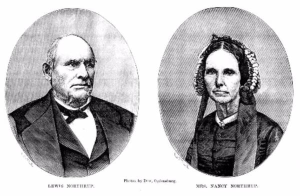
The community of Northrup Corners grew throughout the 19th century at the crossroads of routes connecting the towns of Ogdensburg, Lisbon, and Canton. Historic maps from the mid-19th century show a community with a school, blacksmith shops, and a combined tavern and hotel. The tavern/hotel was located across the road from the L. Northrup site and was owned by Lewis Northrup, Sr. As suggested by the hamlet’s name, by the mid-19th century Lewis Northrup, Sr. was the most prominent member of the community. The Northrup Tavern served as a way station until its destruction in 1928 (Cook 1987:13). The community declined at about this same time, most likely in concert with the spread of automobile transportation. The hamlet’s school closed in 1954 (St. Lawrence Plain Dealer 1954).
Inhabitants of the L. Northrup Site
The L. Northrup Site was occupied by four families between 1831 and 1951. The first known owners were John and Elizabeth Best who lived on the property for almost 20 years. Lewis H. Northrup, son of Lewis Northrup, Sr., who briefly tenanted before moving to a modest home on his parents’ 200 acre farm. William and Margaret Maltby passed from middle to old age there. The Kent family owned the property for the first half of the 20th century. The Bests’ real estate value in 1850 suggests that they were middling farmers like their successors, the Maltbys and the Kents. Lewis H. Northrup seems to have led a very modest existence, with years of tenancy and a large family. All in all, the historic context of the neighborhood is one of economic dominance by larger farmers such as Lewis Northrup, Sr., with their neighbors at the L. Northrup Site composed of middling farm families.
The property lies within a portion of western Oswegatchie known as “Van Solingen’s Tract.” Dr. Henry Van Solingen of New York City does not appear to have ever lived in the region, and was probably a land speculator. He purchased 6,300 acres of St. Lawrence County land in 1821 from David Ogden and other land speculators. An 1824 map on file at the County Clerk’s office shows that Lot 19 (the site parcel) was unoccupied.
In 1831, Van Solingen sold Lot 19 to an English immigrant named John M. Best. He and his wife Elizabeth are documented in the 1840 federal census, and may have built the house at the L. Northrup site. In 1831, both John and Elizabeth Best would have been about 26 years old. The first of their children, Thomas, was born approximately two years later, in 1833. Over the next 10 years, the Best family increased to six children.
In 1854, the Best family sold Lot 19 to William Maltby of Oswegatchie. Maltby was also an English immigrant, while his wife, Margaret, was born in Ireland. The Maltbys apparently did not immediately occupy the parcel, as the 1860 census shows them living in Canton. The 1858 map indicated that the farm was occupied by L. Northrup. The house was probably tenanted by Lewis H. Northrup, son of tavern-owner Lewis Northrup, Sr., who is listed in census records and historic maps as living in the hamlet, across the road from the L. Northrup site. The 1860 census records listed Lewis H. Northrup as a farmer, and showed that he had a modest personal estate of $500, and did not own any land.
The Maltbys moved into their house sometime between 1860 and 1865, as they appeared in the 1865 state census and on the 1865 Beers map. Their household was small, with no children or servants listed in the census records. In 1865, the Maltbys farmed 60 acres, produced five crops, and raised four kinds of livestock. In 1880, William and Margaret Maltby employed a live-in servant, and their nephew, Edward Maltby lived with them. Margaret Maltby passed away in 1884. Edward Maltby continued to live with his uncle after her passing, and in 1892 inherited the farm outright. He and his wife, Emma, chose not to remain on the property for long, and sold it to Thomas Kent in 1894.
Thomas Kent was a farmer who lived at the L. Northrup site with his brother, James, and sister, Jane. James was listed as the head of house in the 1905 census, which described both men as farmers and their niece, Alice, as a school-teacher. When Thomas Kent passed away in 1910, he left a parcel across the road to James and Jane Kent. They also received life use of the “home farm,” though ownership of the farm was passed to Thomas’s out-of-town brothers, Joseph and Daniel. Thomas Kent’s niece, Alice, sold the parcel in 1951.