Phase 1: Exploratory Survey
PAF crews identified The Rosenlund Gatehouse Site during a reconnaissance survey in 2009 for the New York State Department of Transportation. NYSDOT Region 8 was in the process of designing a pedestrian pass under Route 9 that would connect parts of Marist College east and west of the road. As part of the planning process, an archaeological survey was required to comply with the National and State Historic Preservation Acts. The initial survey led to the discovery of 107 historic artifacts from the area north of the gatehouse. Archaeologists established a systematic grid of shovel test pits (STPs), each placed 7.5 m (25 ft) apart and conducted their excavations along this grid. The cultural material collected from the STPs suggested that archaeologists had identified a sheet midden with materials dating from the early to mid-19th century. The material remains and their spatial association with the standing gatehouse allowed PAF researchers to draw an association between the cultural deposits and the Bech Estate's gatehouse.
The site measured approximately 31 m (102 ft) long and 26 m (85.3 ft) wide for a total site area of 624 m² (6717 ft²). The STPs with no artifacts served as the site's boundaries. Based on the results of the survey, PAF archaeologists recommended a Phase 2 site examination as well as archival research to determine the site's eligibility for inclusion in the National Register of Historic Places.
Phase 2: Site Examination
The site examination consisted of the excavation of 10 test units measuring 1 x 1 m (3.3 x 3.3 ft). The units were placed in areas where reconnaissance STPs suggested the potential for high frequencies of diverse artifacts, and in areas that could provide information on the functional use of the yard spaces within the site.
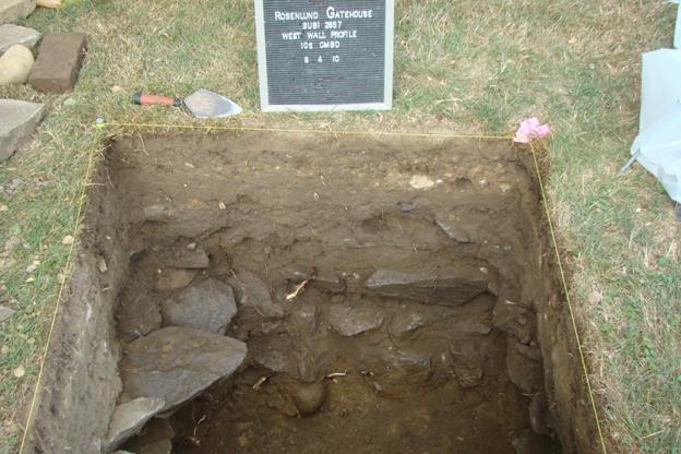
The stratigraphy at the Rosenlund Gatehouse Site included two A horizons (topsoil) overlaying a sterile B horizon (subsoil). The A horizons included historic deposits related to various household occupations and construction activities on the property during the 19th century. The A2 horizon had the most evidence of building activities given it consisted of mottled soils and large cobbles separating the A2 horizon and the B horizon. The A1 horizon was more consistent with sheet midden deposits. In order to assign a date to the deposits, archaeologists used the mean date of manufacture for ceramics or MCD. At PAF, we divide these dates between those artifacts with a definite or closed end date (e.g., 1875), and those that can be manufactured to the present, or open dates. The A1 (open MCD: 1855; closed MCD date: 1825) and A2 (open MCD date: 1834; closed MCD date: 1821) horizons both dated to the early to mid-19th century. A utility trench was encountered in Unit 10. The trench had an open MCD date of 1837 and a closed MCD date of 1809. These earlier dates suggest material from the deposits were used prior to the construction of the gatehouse. At this stage of research, it was uncertain if the deposits reflected a household occupying the property prior to Edward Bech's construction of the Rosenlund Estate or if the material was reflected heirloomed or second-hand pieces.
The site examination produced 1,368 artifacts. These artifacts included architectural, food-related, household, clothing, personal, lighting, smoking related materials, and faunal and food remains. Minor amounts of household, clothing, personal/cosmetic, lighting, and smoking items were recovered. The site contained a diverse amount of data with high research potential that could be informative about early households within the Hudson Valley. Therefore, PAF recommended that the site was eligible for the National Register. The site area with the greatest data potential was the northern yard adjacent to the Gatehouse structure. PAF recommended that these areas with the most potential be avoided during construction if possible. If avoidance was not possible, we recommended a final phase of investigations, a Phase 3 data recovery, to save the information from the site prior to construction. Due to the engineering constraints of the project, impact avoidance was not possible. PAF designed a Phase 3 data recovery for those areas with the potential to increase the relative diversity and density of the assemblage, and contribute to research questions related to the early history of the Hudson Valley.
Phase 3: Data Recovery
A data recovery project was conducted in the summer of 2010. PAF crews conducted additional excavations, photographed the excavation process, recorded information on the site's soil profiles and archaeological features, and developed maps of the site's cultural landscape and archaeological testing. The spatial information collected provided a context for the site's material cultural, which turn allowed archaeologists to better interpret the daily lives of the people who lived at the Van Anden estate and the later Bech gatehouse.
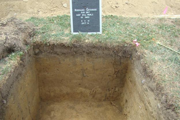
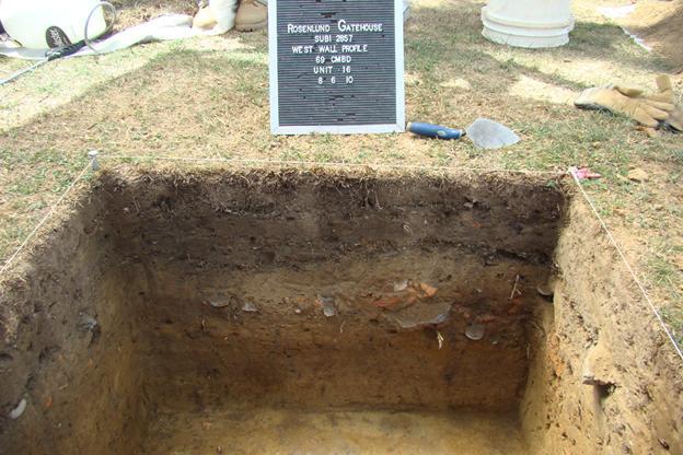
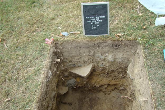
The data recovery excavations consisted of an additional 4 test units measuring 1 x 1 (3.3 x 3.3 ft). With the 10 test units excavated during the site examination, PAF archaeologists achieved good spatial coverage and recovered a large amount of data from the excavations. All data recovery units were positioned using the same grid and coordinate system used during the site examination. The methods used for excavating the test units were the same for both the site examination and the data recovery. Excavations proceeded by hand using shovels and trowels. All soil removed in this manner was screened through ¼ inch wire mesh to standardize recovery of artifacts unless thick, sterile horizons were identified during the systematic sampling. Units were excavated using arbitrary 5 cm (2 in) levels within natural layers of soil. Crews noted and bagged all artifacts by level. The vital information for each unit was recorded level by level on standardized forms. Excavation of each unit continued until two sterile levels within the B-horizon were encountered. Each unit was photographed after it was fully excavated. Additional photos were taken if significant artifacts or features were discovered in a specific level. A profile was drawn at the end of each unit's excavation. The excavators of each unit characterized the soil layers from standardized categories using a Munsell color chart. The interpretations regarding the intactness of deposits on site were made by historical archaeologists trained in the analysis of cultural deposits. Data recovery excavations occurred primarily in the southern two thirds of the site due to the direct impacts from the proposed construction project and the limited research potential of the northern third of the site as determined from the site examination testing. After excavation, an extended period of research, analysis, and report writing commenced.