Archaeologists monitored construction excavation and halted these excavations if possible cultural features were encountered or if intact topsoil was identified within the excavations. In general, excavators removed the top 50 cm (20 in) of asphalt, concrete, and subbase, with archaeological monitoring being conducted from 50 cm (20 in) to a maximum depth of 4.3 m (14 ft) below the surface. For excavations deeper than 4 ft (1.2 m), trench boxes were utilized. Excavations throughout the roadway included parallel trenches heading east to west and laterals cutting north to south across the roadway. During box out excavations, approximately 0.9 m (3.0 ft) of road surface was removed, exposing asphalt, concrete, gravel subbase, and previously placed fill.
During excavations along Oriskany Boulevard, three segments of the south wall of the Erie Canal were visible above the ground surface just to the south of the project boundaries, as well as one segment and possibly other segments of the north wall of the canal, and remains of Lock 46. These remains were designated the Erie Canal Site (SUBi-3246). Originally 40 ft (12.2 m) wide and 4 ft (1.2 m) deep, the canal was expanded between 1835 and 1862 to a width of 70 ft (21.3 m) and depth of 7 ft (2.1 m) and may have been further expanded in portions of the project area in the late 19th century. The canal prism was initially constructed of cut stone walls set in clay, with a clay-lined bottom. A series of locks along the length of the canal raised and lowered the water level for boats to make it over the varied topography of the state.
The Erie Canal Site consists of multiple lengths of Erie Canal wall fragments encountered during excavations along Oriskany Boulevard between Champlin Avenue and Schuyler Street in the City of Utica, Oneida County, New York. The first section of the south wall was identified outside of the project limits on the project plan maps and extending to the east. Portions of this wall were removed prior to monitoring operations in 2018. The remaining two sections of the south wall are present near Jason Street and outside of the project limits, and extend to the east almost to Schuyler Street. A portion of the north wall of the canal was found within excavations near Jason Street approximately 9 m (29.5 ft) south of its intersection with Oriskany Boulevard (approximately 21 m [70 ft] north of the extant south wall of the canal in this area). Portions of the expanded north wall also may have been located along the edge of Oriskany Boulevard from Jason Street to approximately 81 m (266 ft) east of Jason Street. A portion of Lock 46 was also found at the southeast corner of the Oriskany Boulevard and Schuyler Street intersection.

The south wall of the Erie Canal, facing west.

Facing west, south wall of the Erie Canal.

The south wall of the Erie Canal, facing south. Photo shows the ‘seam’ in the south wall of the Erie Canal. The tape measure on the top marks the location of the cuprous pin driven into the stone.

Plan view of the north wall of the Erie Canal.
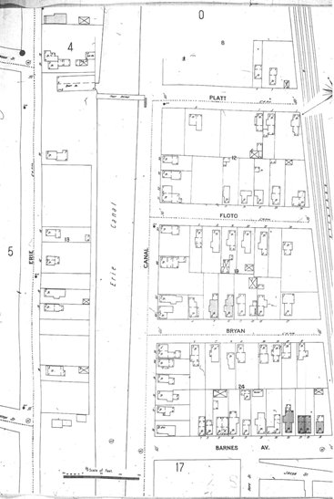
In addition to the mid-19th century north wall of the Erie Canal, possible remnants of an expanded north wall of the Erie Canal may have been identified. By the late 19th century, historic maps suggest that the Erie Canal was expanded in width from west of Schuyler Street to a point west of Platt Street. The maps indicate that the Canal was expanded to approximately 21.3-21.6 m (70-71 ft) south of the edge of the right-of-way on the north side of Canal Street/Oriskany Street. This would place the width of the canal at approximately 100 ft (31 m) wide at Platt Street, reducing down to 81 ft (25 m) by the intersection with Barnes Avenue.
At the intersection of Jason Street and Oriskany Boulevard and at several locations extending to 60 m (200 ft) east, various timbers and some large stones (some limestone), including flat fieldstones, were found adjacent to a buried gas line trench and at the edge of a storm sewer box. Although the stones and timbers do not match the typical limestone construction that is commonly seen along the Erie Canal, photos from the Utica Observer Dispatch show that portions of the Erie Canal also contained areas of fieldstone. Therefore, these stones and timbers may represent demolition of the late 19th century reconstruction of an expanded portion of the Erie Canal.

Example of timbers and stone rubble found near the intersection of Oriskany Blvd. and Jason Street.
Monitoring throughout the remaining project area within Oriskany Boulevard and side streets and on outfall lines identified several wooden box culverts/sewer lines, two foundation walls of a former early 20th century house (Barnes #1 Site), foundation walls, a privy and cistern of the Barnes #2 Site, and the remains of the Durr Meat Packing Plant.

The Barnes Avenue 1 Site foundation, facing east.

Feature 1, privy, within the Barnes Ave. 2 Site, facing east.

Feature 2, cistern, within the Barnes Avenue 2 Site, facing east.