A site files search conducted using the New York State Cultural Resource Information System indicates that there are nine known precontact sites within a 3.2 km (2 mi) radius of the project area. The precontact sites include those dating from the Paleoindian to the Late Woodland periods (12,500 BP-500 BP). Site types include camps, lithic scatters, and stray finds mostly concentrated along the Mohawk River. Arthur C. Parker (1922) described numerous precontact sites in the vicinity of the project area, on both sides of the Mohawk River, including traces of occupation, camps, and a possible trail.
The history of Utica was heavily influenced by the evolution of transportation systems. The Mohawk River is a natural east-west corridor that ties the St. Lawrence and Hudson Rivers, and was a major route for Indigenous people. The first European settlement of this area was Old Fort Schuyler in 1758, located at the site of the future City of Utica. The Euro-American settlement that grew in Utica was located on the banks of the Mohawk, utilizing the natural east-west corridor of the river and becoming the premier crossroads settlement of what was considered “the west” at that time.
The route of the Erie Canal through the downtown of Utica led to the establishment of the city as a major transportation and economic hub of New York State. Construction of the Erie Canal began in 1817 in Rome and worked east toward Utica, passing directly through the project area. The first segment of the canal from Rome to Utica opened to traffic in 1819. The second segment of the canal, linking Rome to Syracuse, opened in 1820. The full canal was completed in 1825. The canal was originally 40 ft (12.2 m) wide and 4 ft (1.2 m) deep with 83 locks to carry canal boats over the varying elevations across 363 miles of New York State from the Hudson River to Lake Erie. The canal was expanded between 1835 and 1862 to a width of 70 ft (21 m) and a depth of 7 ft (2 m) with a reduction to just 72 locks. During this expansion, the size of the locks was increased to 110 ft (34 m) long and 18 ft (6 m) wide. The enlargement also included the doubling of the locks, making what was a single lock into two parallel chambers, enabling traffic to proceed in both directions at the same time.
In 1884, work began on lengthening the locks, extending one chamber to double length, and allowing passage for “double-headers” (two boats hooked together) without the time-consuming necessity of uncoupling. Lengthening of the first lock, Lock 50, to 220 ft (67 m) was completed in 1885. By 1891, Lock 46 (located within the project area) had been lengthened to 220 ft (67 m) (www.eriecanal.org).
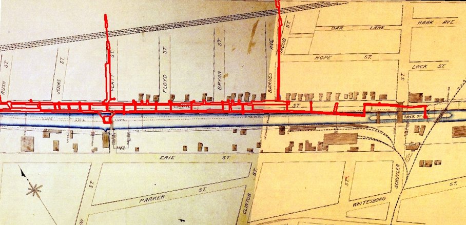
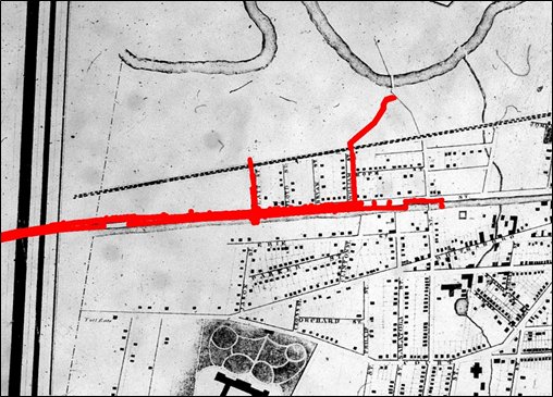
Historic maps from 1829 through 1899 show the route of the Erie Canal to the south of the project area, specifically the southern edge of present-day NYS Route 5A. These maps indicate that the Erie Canal extended the length of the southern edge of what is now Oriskany Boulevard’s south lane, with the towpath located along the north edge of the canal (the south lane of Oriskany Boulevard). Canal Street was just north of the towpath, located roughly in the path of the north lane of present-day Oriskany Boulevard. Portions of the project area were identified on the 1888, 1899, 1925, and 1945 Sanborn Fire Insurance Maps. These maps show that the project area was located on the rapidly developing west end of Utica. The 1888 map is the first to show Lock 46. Traffic on the Erie Canal was brisk and steady through the late 19th century; the canal was shut down to traffic following the opening of the Barge Canal north of the project area in 1918.

View of the Erie Canal c. 1885-1891, facing west. The towpath/Canal Street is located to the right, and Lock #46 is visible far to the west (www.eriecanal.org).
On the 1925 Sanborn Map most of the canal has been filled in, with this area now represented by wide open lots, sometimes with a few buildings scattered across it. Small sections of the canal were left open. Since the late 1880s contracts were granted to companies for the purpose of filling in the canals which were being shut down. For example, one contract granted to fill in the Chenango Canal stated that the canal was not to be filled with garbage; only clean fill was to be used. By 1945 the Erie Canal had been entirely filled in.