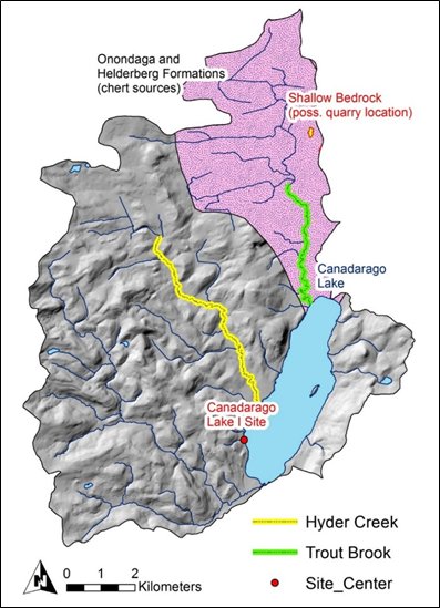
The Canadarago Lake I site occurs within the drainage basins for Hyder Creek and Trout Creek in northern Otsego County and the site overlooks the western shore of Canadarago Lake. The drainage basins form a transitional zone between the glaciated Appalachian Plateau and the Erie-Ontario glacial lakeplain. The topography ranges from rugged till plains and hills at the southern limits of the basins to smoother rolling hills and flatter drumlin plains at the middle and northern third of the basins. The northern end of the drainage basins also overlaps the Onondaga and Helderberg limestone formations.
The Canadarago Lake 1 site is located adjacent to a high gradient 1st order unnamed tributary stream, with the base of the valley wall rising gently to the west. The stream originates in a large depression on the western valley wall and falls over 180 meters (591 ft) over its course. Soils within the vicinity of the site are derived primarily from glacial till deposits of Conesus and Lansing silt loam. Both types typically occupy hills, plains, or drumlin landforms. Predicted forest types within the site area likely included mesic floodplain forests and semi-mesic pine-hemlock-northern hardwood forests in the precontact period. Potential mast species within the immediate site area may have included hazelnuts, acorns, and beechnuts.
