Precontact Site Use
The precontact history of this portion of the Chenango and Susquehanna River Valleys begins as early as 8,000 BC. Early Archaic projectile points, styles dating as early as c. 8,000 BC, were recovered during archaeological excavations at the Roberson site near the confluence area. We have more substantial evidence of Indigenous occupation from the Late Archaic to Late Woodland periods (c. 4,000 BC to AD 1550), which suggests that the confluence of the Chenango and Susquehanna Rivers was intensely utilized during most of the precontact period. The Chenango Point/Chenango Point South site is located directly to the south of the 7 Hawley Street project area. It is likely that Indigenous occupation of the 7 Hawley Street project area is related to this larger site complex.
The Chenango Point/Chenango Point South site is a large precontact occupation focused on the confluence of the Susquehanna and Chenango Rivers (Knapp 2011; Miroff 2013). Excavations at the site revealed that it was occupied at multiple periods in time, including during the Late Archaic (3600-3400 BC), Transitional (1500-1000 BC) and early part of the Late Woodland (AD 800-1350). In the northern portion of the site, archaeologists identified a deep pit dating to the Late Archaic that appeared to have been used as a cache area, suggesting these seasonally nomadic hunter-gatherers had stored stone tools and other items for return visits. A longhouse was also present on this portion of the site indicating the presence of more permanent occupation during the Late Woodland. Storage pits (for agricultural products) and cooking hearths were located around the longhouse. The southern portion of the site showed more impacts by 19th and 20th century historic development. However, data indicates that people used this area into the sixteenth century, suggesting a slight in settlement over time.
Initial archaeological testing in 1989 at the 7 Hawley Street project area did not produce any precontact material culture or cultural features. However, the area’s proximity to the Chenango Point/Chenango Point South sites meant Indigenous occupation could not be completely ruled out when PAF returned in 2018.
Post-Contact Site Use
The 7 Hawley Street site is located in the heart of Binghamton’s early 19th century commercial core, which centered on the main thoroughfare of Court Street as it intersected the Chenango River. The northern portion of the block on which the project area is located fronted Court Street less than one block from the Chenango River and saw intensive early commercial development. The 7 Hawley Street project area encompasses the southern third of the block along Hawley Street, which remained relatively undeveloped until the late 19th century. As Binghamton transformed into an urban center, this valuable real estate became a densely packed area of shops, light industry, hotels, and working-class housing.
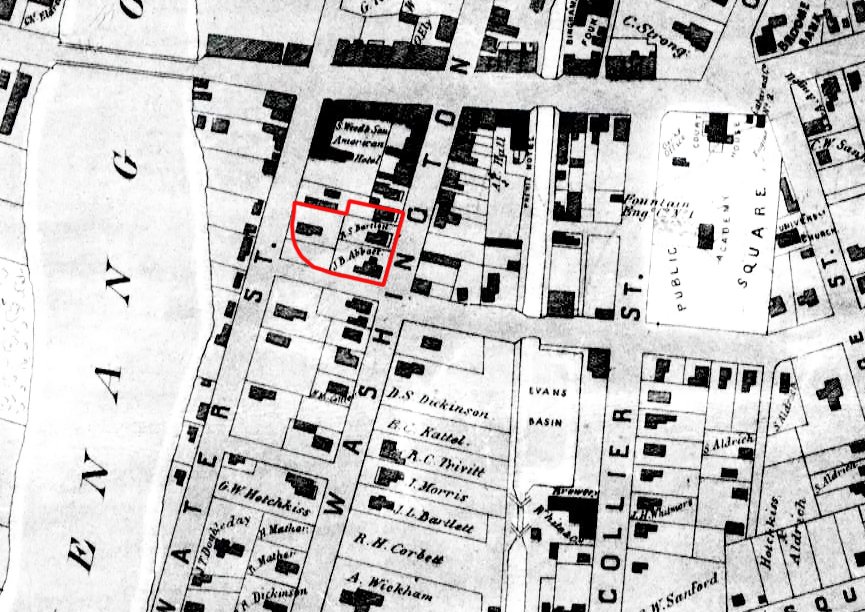
Jeremiah Campbell purchased most of the lot that became the 7 Hawley Street project area from Elihu Ely in 1822. Ely was a major land speculator in early Binghamton. The purchase price of $330.00 suggests the lot was not significantly developed, but just three years later the 1825 Moore map shows four structures. Campbell lost little time subdividing the large lot; he kept the western half of the lot and in 1825 sold the eastern half along Washington Street to Ammi Doubleday, another property speculator. Maps from the mid-19th century show three to four structures, all on large lots, in this southern section of the block. Census data indicate these structures were primarily single-family homes. The Abbott and Bartlett families were both early residents of the area, occupying large lots along Washington Street. Joseph B. Abbott was one of Binghamton’s earliest settlers and a successful tanner, while Robert Bartlett owned a gun factory with his brothers.
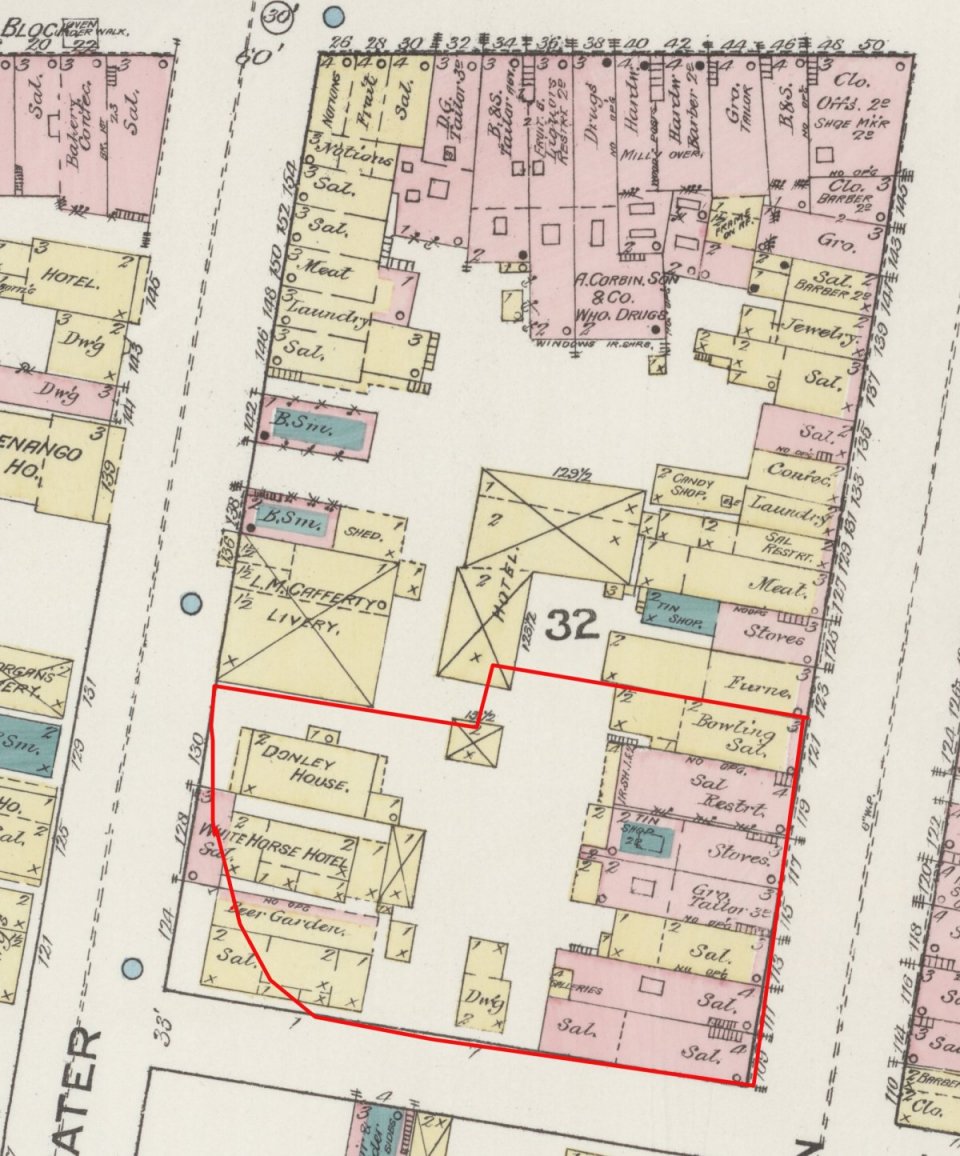
The character of this area changed as the early 19th century residents sold off their house lots. From 1864 to 1867, Joseph M. Gandolpho and Carlos Cortesy began buying property within this southern portion of the block and further subdividing the lots for resale. In less than a decade, the two large single-family homes along Washington Street were removed and a solid block of row structures was erected, another building was added to the two fronting along Water Street, and property was taken off the rear of existing lots to create two narrow parcels facing Hawley Street. This rapid development is typical of what was happening throughout Binghamton’s commercial core in the period immediately following the Civil War as commerce and industry expanded.
In the late 19th and early 20th centuries, the 7 Hawley Street project area was a mixed commercial/residential area with some light industry. Commercial enterprises in this period were primarily aimed at working class leisure, such as saloons, billiard saloons, and bowling alleys. A grocer and stove and tin shop were also located within the row structures on Washington Street in the late 1880s. Apartments over the saloons and shops supplied residential space, as did the hotels located along Water Street. These establishments were more akin to lodging houses or residential hotels. The concentration of saloons and the dense urban character did not create a healthy living environment and most of the tenants and lodger/guests of the hotels were working class.
This area was significantly impacted by urban renewal in the late 1960s. The western end of Hawley Street was completely rerouted for one of Binghamton’s major urban renewal projects - construction of the current Holiday Inn Hotel and the former Merrill Lynch building and their respective parking areas. Hawley Street was shortened and looped up to meet Court Street, which cut off the corner of the intersection of Hawley and Water Streets. A photo taken during the construction shows some of the impacts to the southern portion of the project area during urban renewal. At least one of the row structures at the corner of Hawley and Washington, shown as standing on a 1963 map (Sanborn Fire Insurance Map), is no longer present and the entire length of Water Street in the project area was leveled along with two structures that were also still extant in 1963. The remaining row structures along Washington Street within the project area were removed by 1970 and the area turned into a parking lot. The area has not been redeveloped and has functioned as a surface parking lot since urban renewal.

The 7 Hawley Street project area (outlined in red) on the 1851 Bevan map.

The 7 Hawley Street project area (outlined in red) on the 1887 Sanborn Fire Insurance map.